
Rain Gardens
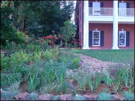 Rain gardens are storm water drainage areas that temporarily store rainwater until it can filter into the soil. Rain gardens do not permanently store water, and have surface water only during and shortly after rainfall events.
When properly designed, rain gardens should have surface water for only few days, which is not long enough for mosquito eggs and larvae to develop into adults. The benefits of creating a rain garden include:
- The reduction of flooding at drainage inlets and downstream areas.
- It filters pollutants from urban runoff which can affect streams and creeks.
- Prevents erosion by reducing storm water volume and velocity.
Rain gardens work by collecting surface water in a depression in the ground and then filtering the water through soils and plants. The biological and chemical processes within the soil, plants, and mulch are able to store or break down pollutants and improve water quality.
Rain gardens are best located in the main drainageways on a property, or in lower depressions where water sometimes pools. These are easily seen during a medium size rain. Here are a few tips to consider when locating a rain garden spot:
- Always contact your utility company to come out and locate any buried lines or pipes on your property. Since most rain gardens require soil excavation, determine and avoid these locations.
- Do not place rain gardens in or near septic drainage fields.
- Place rain gardens downslope from any structure and avoid placing near building foundations.
- Select areas that are open and away from large trees. Excavation can damage the roots of a tree, and excess water in these areas could damage tree health.
- Avoid steep slope areas (over 12%) for rain gardens.
Understanding the soil types on your property is key to a successful rain garden. As the purpose of a rain garden is to drain into the surrounding soil, sandy soils are typically best. Clay or compacted soils may need a larger excavation area and be replaced with a loose soil mix, or may require additional underground drainage. Your local county Extension professional can provide you with soil sample boxes for soil tests. A simple way of testing your soil drainage is to dig a hole about the size of a two gallon bucket. Fill it with a bucket of water and let it percolate. If it drains less than an inch per hour, you may need to provide additional drainage measures, such as an outflow pipe or French drains (perforated pipe in a rock channel) that carry the overflow water safely to an outlet. If soil erosion occurs around the rain garden outflow, permanent materials such as rock or concrete may be necessary to secure the edges.
Although any size rain garden can help storm water to some degree, if you have severe erosion or flooding problems, it may require a professional engineer or landscape architect to address the problem. Most raingardens are not designed to handle the volume of water from heavy storms or retain all of the stormwater from the property. Instead, they are normally smaller pockets of infiltration. Large properties or sites with significant amounts of impervious surfaces (large roofs or parking lots) may need a retention or detention pond to handle large water volumes.
It is often recommended that 5-7% of the total watershed should be accommodated for in the raingarden, and you may need to calculate the size of your site watershed. Most residential properties are graded to carry water to a lowest point. Your watershed includes any impervious surfaces (constructed items that do not allow any water percolation such as roof tops, driveways, sidewalks, or patios) and pervious surfaces (vegetated areas that allow some water percolation such as lawns and garden areas).
To calculate the size of your watershed, estimate the total square footage by multiplying the width times the length of the entire property that drains into your proposed rain garden area (including all building roof sizes, lawns and paved areas). Vegetated areas have some soil percolation, but as many residential or commercial areas have compacted or clay soils, percolation may be negligible. This may be done for small properties by using a measuring tape, for large properties you may need a scaled property plan to approximate square footage. See the following example of how to calculate a rain garden size for an average single family home on a third acre lot.
Total watershed square feet: 14,375 ft2 (one-third acre) One acre is 43,560 square feet.
| 5% of watershed: | .05 |
| Total rain garden sq. ft. | 719 ft2 |
A rain garden that can accommodate 5% for one-third of an acre property should be approximately 700 ft2 in size. It may be any configuration (20 feet by 35 feet, or 10 feet by 70 feet) and the recommended depth to allow for water pooling to the top of the soil or soil replacement is six inches. This shallow depth also minimizes injury if someone steps into the rain garden. For clay soil types, the soil should be excavated and replaced with a well draining soil type. It is often recommended for clay soils to replace at least three feet of soil with loose soil mix: such as 50% sand, 25% topsoil, and 25% compost or shredded mulch. This composition allows for good drainage (sand), and root growth and microbial organisms (topsoil and compost). As you can see, this is a considerable volume of excavation that would require heavy equipment and contracting cost.
As rain gardens are often as dry as they are wet, it is best to choose plants that can tolerate a wide range of moisture regimes. Depending upon how your garden is built, you may notice some areas that stay wetter than others. Usually it is best to select plants that can tolerate drought as well as occasional flooding. Below is a list of plants suitable for rain gardens in the Gulf South, arranged by plant type.
|
Small and Large Trees |
|
| Common name | Scientific name |
| Swamp red maple | Acer rubrum var. drummondii |
| Bald cypress | Taxodium distichum |
| Green ash | Fraxinus pennsylvanica |
| Swamp black gum | Nyssa sylvatica var. biflora |
| Willow oak | Quercus phellos |
| Black willow | Salix nigra |
| Sweet bay magnolia | Magnolia virginiana |
| Pond cypress | Taxodium ascendens |
| Mayhaw | Crataegus opaca |
| Ironwood | Carpinus caroliniana |
| Wax myrtle | Myrica cerifera |
|
Shrubs |
|
| Gallberry holly | Ilex glabra |
| Yaupon holly | Ilex vomitoria |
| Dwarf palmetto | Sabal minor |
| Chokeberry | Aronia arbutifolia |
| Buttonbush | Cephalanthus occidentalis |
| Summersweet | Clethra alnifolia |
| Sweetspire | Itea virginica |
| Titi | Cyrilla racemiflora |
| Buckwheat tree | Cliftonia monophylla |
|
Perennials |
|
| Joe pye weed | Eupatorium fisulosum |
| Cardinal flower | Lobelia cardinalis |
| Stokes aster | Stokesia laevis |
| Rose mallow | Hibiscus lasiocarpus |
| Texas star hibiscus | Hibiscus coccinea |
| Louisiana iris | Iris spp |
| Boltonia | Boltonia asteroids |
| Coreopsis | Coreopsis lanceolata |
| Swamp sunflower | Helianthus angustifolius |
| Blue flag iris | Iris virginica |
| Blazing star | Liatris spicata |
| Cinnamon fern | Osmunda cinnomomea |
| Royal fern | Osmunda regalis |
| Goldenrod | Solidago canadensis |
| Ironweed | Vernonia spp. |
| Obedient plant | Physostegia virginiana |
| Horsetail | Equisetum hyemale |
|
Grasses and Sedges |
|
| River oats | Chasmanthium latifolium |
| Blue sedge | Carex glauca |
| Woolgrass | Scirpus cyperinus |
| Muhly grass | Muhlenbergia capillaries |
| Panic grass | Panicum virgatum |
| Little bluestem | Andropogon virginicus |
| Spikerush | Eleocharis spp. |
The following public Web sites have additional information about rain gardens:
These factsheets were written by Robert F. Brzuszek, Assistant Extension Professor, The Department of Landscape Architecture, Mississippi State University.

Publications
News
")

Mississippi growers and those across the Midwest and mid-South still have time to take advantage of two opportunities to improve soil health and water quality while protecting profitability on their farms.
")
Success Stories

Fenton Pope looked around his native Covington County a quarter-century ago and saw what he believed was an alarming amount of farmland out of production.

Billy Mitchell spent his childhood summers in the water and has lived at Pelahatchie Bay for more than three decades, so his dedication to protecting water resources now almost makes too much sense.

Cruising into Madison County, you see a cultivated urban landscape full of brick edifices and manicured lawns spring up around you. Your cell phone announces your turnoff, and you comply, turning onto an older road that soon turns to gravel.