
The Great Red Snapper Count: Habitat Classification
This publication describes the habitat classification phase of the Great Red Snapper Count, which is a 2-year research project to estimate the abundance of red snapper in the U.S. Gulf of Mexico.
Where do red snapper live in the U.S. Gulf of Mexico?
- Red snapper are distributed across a variety of habitats.
- The seafloor consists primarily of sand and mud, along with natural reefs; these areas provide habitat for red snapper.
- Concentrated areas of artificial structures also serve as red snapper habitat.
- The coverage of sediments, natural reefs, and artificial structures differs dramatically across the Gulf.
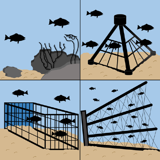
What types of artificial structures exist in the Gulf?
- Large oil and gas platforms are common in the western Gulf.
- Smaller structures (chicken transport cages, pyramids, military tanks, planes, car bodies, and others) are deliberately placed on the sea floor to create fish habitat.
What is habitat classification?
- Habitat classification is Phase 1 of the Great Red Snapper Count.
- This phase involves determining where each of the various habitat types exist across the Gulf.

How did scientists approach the classification process?
- U.S. Gulf waters were separated into four regions: Texas, Louisiana, Mississippi-Alabama, and Florida.
- Each region was divided into three depth zones, creating 12 unique sections.
- For each section, scientists compiled existing data from various sources to characterize known habitat features.
What did scientists learn from this process?
- Scientists calculated the amount of the U.S. Gulf sea floor that is covered by sand, mud, and natural reefs.
- Scientists also determined the quantity of existing artificial reef structures.
Why is this information useful?
- Based on the distribution and number of different habitat types, scientists decided which sampling approaches, or “gear types,” to use in the Great Red Snapper Count.
- This will result in the best possible estimate of red snapper abundance in each section of the U.S. Gulf of Mexico.
This independent study is being conducted by a leading team of red snapper scientists from across the Gulf of Mexico and beyond:

This publication was supported by the U.S. Department of Commerce’s National Oceanic and Atmospheric Administration under NOAA Award NA16OAR4170181, the Mississippi -Alabama Sea Grant Consortium, and the Mississippi State University Extension Service. The views expressed herein do not necessarily reflect the views of any of these organizations.
Publication 3282 (POD-10-18)
MASGP-18-019-02
By Amanda E. Jefferson, Extension Associate, and J. Marcus Drymon, PhD, Assistant Extension Professor, Coastal Research and Extension Center.
Produced by Agricultural Communications.
Mississippi State University is an equal opportunity institution. Discrimination in university employment, programs, or activities based on race, color, ethnicity, sex, pregnancy, religion, national origin, disability, age, sexual orientation, genetic information, status as a U.S. veteran, or any other status protected by applicable law is prohibited. Questions about equal opportunity programs or compliance should be directed to the Office of Compliance and Integrity, 56 Morgan Avenue, P.O. 6044, Mississippi State, MS 39762, (662) 325-5839.
Extension Service of Mississippi State University, cooperating with U.S. Department of Agriculture. Published in furtherance of Acts of Congress, May 8 and June 30, 1914. GARY B. JACKSON, Director

The Mississippi State University Extension Service is working to ensure all web content is accessible to all users. If you need assistance accessing any of our content, please email the webteam or call 662-325-2262.


