
Forest Soils of Mississippi
People often take the importance of soil for granted. Soils provide the foundation for our homes, cities, and roads, and they also serve as the medium for crops and forests. Soils store and filter the groundwater that nourishes our lives. They provide for the diversity of plants and wildlife that Mississippians depend on for commerce and recreation.
Landowners interested in making the most of their forest need a basic understanding of soils. Forest productivity and the production of wildlife habitat hinge on soil quality. Knowing proper soil management techniques is crucial to conserving the land and protecting watersheds from soil erosion.
Soil Formation
Soil forms through interactions of physical, chemical, and biological mechanisms on geological materials exposed to the earth’s surface. Essentially, soil is the product of weathering from climate and organisms acting upon a geological parent material. These processes are affected by local topography over very long periods of time. Soil takes hundreds to thousands of years to develop in the landscape. This means soil is not a renewable resource, even though crops and forests grown on the soil are.
Parent Material
Exposed geologic formations provide parent material for the development of soil. The oldest geologic formations in Mississippi occur in the northeast corner of the state. These deposits are from the erosion of what we now call the Appalachian Mountains, and are as much as 250 million years old.
The geology for much of the rest of the state is dominated by the Mississippi Embayment. This trough began to form in the late Cretaceous period, perhaps some 70 million to 80 million years ago. This trough covered much of what is now Mississippi, northern Louisiana, eastern Arkansas, westernmost Tennessee, and north to Cairo, Illinois. The embayment formed an inland sea, extending what we now call the Gulf of Mexico. Over time, this trough was filled by sediments from the erosion of the Appalachian and Ouachita Mountains. As the embayment filled, the earth’s crust also rose, and the Mississippi Embayment was transformed into the Gulf States.
The most recent soils of the Mississippi River floodplain formed from sediment during the Ice Age some 1 million years ago and ending 10,000 to 12,000 years ago. The Mississippi River drained immense glacial lakes farther north that formed as the great ice sheets melted. Wind-blown deposits of this glacial outwash formed the Loess Hills bordering the Delta region to the east. Altogether, sedimentary deposits are easier to weather than rock. The most recent alluvial sediments in the Delta are very fertile and are the basis for the success of Mississippi’s agricultural industry.
Climate
Mississippi has a warm, humid climate. Weather patterns are dominated by the continent to the north and the Gulf of Mexico to the south. During the summer, average daytime temperatures are typically in the 80s or 90s. Annual average winter temperatures are in the 40s in the north and 50s along the coast.
Average annual precipitation increases moving southward across the state, with around 50 inches falling in north Mississippi and 65 inches at the coast. The frequency of thunderstorms also increases moving southward, from about 55 days per year in the north to 75 days at the coast.
This warm, humid weather accelerates weathering of parent materials that make up the geology of the state. Weathering involves the biological processes and chemical reactions that transform parent material into soil, which occur faster as the temperature rises.
The soils of the Coastal Plain in southern Mississippi are more weathered than those in river bottomlands. The soils of the river bottoms, including the Mississippi River floodplains, are much more variable than Coastal Plain soils in terms of fertility, degree of weathering, and development. This has implications for agriculture, forestry, and wildlife management.
Organisms
Mississippi has a great variety of vegetation from north to south and east to west, forming major ecoregions across the state. These areas include the Mississippi Delta, which is dominated by agriculture and bottomland hardwood forests. Forests in the Delta include numerous bottomland species, such as bald cypress, willow oak, swamp chestnut oak, cottonwood, black willow, green ash, sugarberry, and swamp hickory.
To the east of the Delta are the Loess Hills. The vegetation in the Loess Hills region is dominated by cherrybark oak, yellow poplar, water oak, mockernut hickory, and sweetgum. Also, these soils have some of the highest productivity for loblolly pine in the state.
The northern part of the state is within the Upper Gulf Coastal Plain. Vegetation is dominated by oak-pine and oak-hickory forests. Common species here include shortleaf and loblolly pine, upland oaks (such as southern red, white, post, scarlet, black, and blackjack), hickory, and sweetgum.
The Blackland Prairie region has soils with relatively high alkalinity. Vegetation in this region must be tolerant of higher soil pH. Common species are eastern red cedar, post oak, shumard oak, green ash, and hickory.
The Lower Coastal Plain and Northern Gulf of Mexico regions are dominated by upland forests of longleaf pine, slash pine, and upland oaks (such as live oak and southern red oak). Longleaf pine is well-adapted to the frequent, low-intensity fires that burned across this landscape. Slash pine, while tolerant of fire as a mature tree, is less tolerant as a seedling or sapling and is typically confined to wetter sites. Live oak is very hardy and tolerates high winds of tropical storms and saline soils along the coast. Bottomland species in this region include American elm, bald cypress, green ash, sugarberry, water oak, and red maple.
Pine and oak vegetation tend to produce organic acids upon decomposition due to their oleoresins and tannins, respectively. Their decomposition will tend to acidify soils, which further accelerates mineral weathering of geologic sediments.
Prehistoric humans also influenced the Mississippi landscape through fire. As Native American cultures developed agriculture, humans used fire more extensively. This tool was used to clear land for farming and to keep hunting grounds open. Consequently, pre-Columbian civilizations created a mosaic of villages, agricultural fields, and extensive woodland-savannas in Mississippi. Therefore, native vegetation adapted to very frequent burning.
Topography
The effects of topography on soil formation occur on a smaller, local scale. First, local relief of the land affects internal drainage through the soil. A common observation is that soils on higher positions, such as ridges, are dry, while those in lower positions, such as ravines and wide floodplains, are wet. These differences in drainage will affect the types of chemical reactions involved in weathering of parent material into soil.
Secondly, available moisture has a tremendous influence on the kinds of vegetation growing across the landscape. This, in turn, affects animals living in these areas. Altogether, these differences in plant and animal communities from one area to the next will also influence the weathering of parent materials into soil.
Time
The floodplains are the youngest, most fertile, and most highly variable soils. Otherwise, soils found in Mississippi tend to be very old. These old soils are highly weathered and lower in nutrients than river bottomlands.
Prehistoric vegetation was very different from today’s. However, it still responded to changes in soils and climate. As the last Ice Age was ending, 10,000 to 12,000 years ago, beech, hornbeam, oak, white pine, and hemlock dominated Mississippi forests. Since this vegetation was adapted to cooler climates, weathering processes also changed and slowed.
Yet as vegetation developed on bare ground, organic matter was gradually incorporated into the soil-forming processes. As the climate warmed, forest composition in Mississippi gradually developed to that which is seen today, with the southern pines, oaks, red maple, and sweetgum. Further, organic acids from decaying pine needles and oak leaves accelerated the weathering process.
Describing Soil Layers
Over time, soil-forming processes transform geological parent material into soil. Intensive weathering occurs near the soil surface. This weathering dissolves and transports minerals downward through the soil. As the minerals move downward, chemical and physical interactions in the soil change, with new minerals created and deposited. This results in the formation of layers, or horizons, in the soil. These layers are characteristic of the geology, hydrology, chemistry, and vegetation on a site. Horizons and their properties are used to describe the soil (Figure 1). Horizons are called O, A, E, B, C, and R.
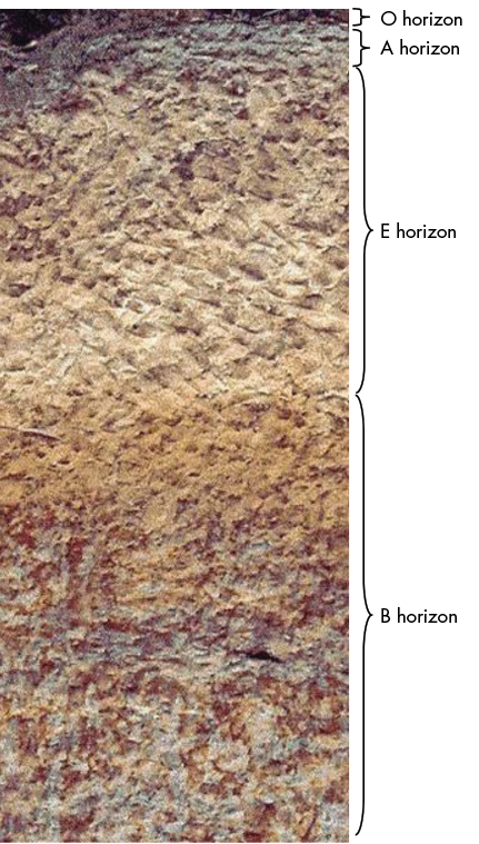
O Horizon
The O horizon is on the soil surface and consists of leaves, branches, and other organic materials in varying stages of decomposition. In forests, this horizon is divided into litter and duff layers. While the O horizon is not a part of mineral soil, it is very important. It is in the litter and duff layers that organic material is recycled, with nutrients being returned to the soil through decomposition. These layers also help prevent wind and water erosion of soil particles.
A Horizon
The A horizon is called topsoil. It is a combination of mineral soil and organic matter that has been incorporated from the litter layer. The topsoil is a zone of leaching, as water moving through the soil washes minerals off soil particles.
E Horizon
Occasionally, there is a layer beneath the topsoil called the E horizon, which is also a zone of intense leaching. Consequently, this layer is comprised predominantly of washed sand grains. This layer is commonly found in highly weathered soils of the Lower Coastal Plain and Coastal Flatwoods in southern Mississippi.
B Horizon
The B horizon is the beginning of the subsoil. This is a zone of accumulation, usually of clay minerals or compounds of iron, aluminum, and organic complexes. For many Mississippi soils, the B horizon is generally the next most fertile horizon after the A horizon.
C Horizon
The C horizon is usually deeper subsoil, considered to be residual parent material from which the soil formed. It bears the effects of weathering but with relatively little influence from soil organisms, as compared to the O, A, E, and B horizons.
R Horizon
The R horizon is found beneath the C horizon and is the original bedrock. In Mississippi, the R horizon is found in soils of the Appalachian foothills, in the northeasternmost corner of the state.
Soil Properties
There are several soil chemical and physical properties that are important to forest management. They are organic matter, texture, porosity, drainage, and soil pH. These physical and chemical properties of soil interact to determine its fertility. This concept is known as “carrying capacity.” Essentially, a given unit of land can produce a set amount of biomass, measured as yield. The following sections include more detailed descriptions of these key soil properties, which are vital to soil fertility.
Soil Organic Matter
Organic matter is a vital component to soil fertility. Organic matter helps retain plant nutrients and moisture. It also helps development of soil structure, which is how individual soil particles bind together. Good soil structure leads to more and larger pore space, which is necessary for internal drainage and adequate aeration for plant roots. Organic matter decomposes into acidic materials, which further enhance chemical decomposition and weathering of parent material and influence soil acidity.
Plants and animals are the sources for organic matter. Since natural vegetation for most of Mississippi is forest, organic matter often accumulates in litter and duff layers atop mineral soil. Soil organisms such as springtails and millipedes eat and break down the litter layer into finer material that constitutes the duff layer. Other soil organisms, including fungi, microbes, and earthworms, continue decomposition of the duff and further transform organic matter into humus. Eventually, some of the humus is mixed with mineral soil to form the A horizon.
Soil Texture
Soil texture is the proportion of different particle sizes of soil material. Sand has the largest particles, followed by silt, then clay. Texture can be determined by two methods: separation of size fractions in the lab, and by feel in the hand.
Texture by feel in the hand is determined by how well moist soil sticks together. Sandy soils have individual grains that feel gritty. If the soil holds its shape (known as a cast), it is loamy. If the cast can be rolled into thin ribbons between the fingers, that indicates clay.
Traditionally, clay soils were referred to as “heavy” because the soil stuck to the plow and made it heavy. By contrast, sandy soils were known as “light” soils because the sand grains did not stick to the plow.
Soil Porosity
Soil is not a solid mass. The spaces between soil particles are called pores, and they allow water and air to move through the soil. Porosity is measured as the proportion of void space in a given volume of soil. Ideally, nearly half the volume of soil should be pore space.
Large pores allow internal drainage of water through soil and aeration for roots. Small pores are essential for retaining water for root absorption.
If soil is too dense, plants cannot absorb sufficient water and air. Insufficient pore space, therefore, may restrict root and plant growth or even lead to death. Further, roots cannot penetrate highly compacted soil where pore space has been removed.
Soil Drainage
The position of soil in the landscape determines depth to the seasonal water table. Wet soils (very poor, poor, and somewhat poorly drained) will have a high water table for some portion of the growing season. Root growth may be restricted due to excessive moisture and limited aeration for respiration. On the other hand, drier soils (moderately well, well, and excessively drained) have a deeper water table. As drainage improves on drier sites, moisture may become limited during the growing season.
Soil pH
Soil pH is a measure of acidity or alkalinity, which is the concentration of hydronium ions in the soil solution on a negative logarithmic scale. A soil pH of 7 is neutral, a pH value less than 7 is acidic, and a pH value greater than 7 is alkaline (also known as basic). Soil pH influences nutrient uptake and tree growth.
Many soil nutrients change chemical form as a result of reactions in the soil that are largely controlled by pH. Soils with a pH between 6.0 and 7.0 generally have the best growing conditions with regard to soil chemistry. At these pH levels, most nutrients are readily available. Nevertheless, the vast majority of commercially important tree species can live in a broad range of soil pH values as long as the proper balance of required nutrients is maintained.
Soil pH values at the extremes (less than 4.0 or greater than 8.5) can make some nutrients toxic and others unavailable to plants. At lower pH levels (less than 4.5), aluminum, iron, and manganese are very available for plant uptake, while at high pH levels (greater than 8.5), calcium and potassium are overabundant. In these situations, many plants will absorb too much of some nutrients and not enough of others. This situation may lead to physiological dysfunction within plants.
Major Soil Resource Areas
In Mississippi, there are several major soil resource areas (Figure 2). These predominant soils and composite vegetation define major ecoregions across the state. These are the Delta, Loess Hills, Upper Coastal Plain, Blackland Prairie, Lower Coastal Plain, and Flatwoods.
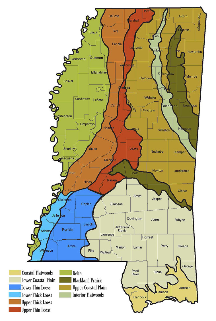
Delta
The Delta region of western Mississippi is part of the Mississippi River floodplain. Soils here are moist to wet, with medium to heavy texture. Historically, this region was covered by bottomland forests of cypress and oak. Clearing for agriculture began in the mid-1800s. Most of this area is in agricultural production, with a small proportion of land in bottomland hardwoods and pasture. Soybeans, cotton, wheat, and rice are the main crops.
Loess Hills
Adjacent to the Delta to the east are the Loess Hills, formed from wind-blown glacial outwash some 10,000 to 12,000 years ago. These silty upland soils are deep, well drained, and fertile. Forest production predominates, although agricultural production of cotton, corn, soybeans, and wheat is important.
Upper Coastal Plain and Interior Flatwoods
The Upper Coastal Plain and Interior Flatwoods major soil regions are in the northeastern section of the state. The soils in these regions are older and more highly weathered, so they are less fertile than those to the west. These soils display advanced soil development, with well-defined topsoil and subsoil horizons. Mixed pine-oak forests predominate, with loblolly and shortleaf pines and a variety of upland and bottomland oaks. Major crops include soybeans, corn, peanuts, and vegetables. Pastures are a minor crop.
Blackland Prairie
Interspersed within the Coastal Plains is the Blackland Prairie ecoregion. The Prairie soils bisect the northern and central portions of the state. Having developed from more chalky sediments, soils in this region are fine-textured with shrink-swell clays. Soil pH tends toward alkalinity. While forestry is significant, there is a greater amount of pasture and cropland in this region.
Lower Coastal Plain and Coastal Flatwoods
In the southeastern corner of the state are the Lower Coastal Plain and the Coastal Flatwoods along the Gulf of Mexico. Predominant soils are sandy and wet with low native fertility. Forests cover nearly 90 percent of the area. The proximity of the coast caused natural vegetation here—including longleaf pine, slash pine, and live oak forests—to adapt to tropical storms and saline soils.
Soil Management
Proper soil management requires a long-term commitment by landowners to sustain key soil properties. They must:
- protect the soil from erosion.
- maintain good physical condition of the soil.
- maintain proper balance of soil chemistry.
- maintain and enhance the organic components of the soil.
Management techniques will vary widely depending on land use, soil region, specific location, and topography of a given property.
Landowners are strongly encouraged to obtain a detailed soil map of their property from the Natural Resources Conservation Service (NRCS). These maps are available in the local NRCS office or online at https://websoilsurvey.sc.egov.usda.gov/App/HomePage.htm. The manuals and maps on the website provide a great deal of useful information, including drainage, fertility, best tree species to plant or manage, and development ratings.
The Mississippi State University Extension Service soil testing laboratory can determine site-level soil properties for a modest fee. Forms and soil sample boxes are available at the local county Extension office.
Routine soil testing through MSU Extension includes soil pH, liming requirements, and the amounts of available nutrients. If you specify a crop, fertilizer recommendations will also be included. Many helpful publications on interpreting soil test results for timber, horticulture, agriculture, and wildlife food plots are available at https://extension.msstate.edu/publications.
When conducting forest operations on your property, such as harvesting or spraying herbicides, it is important to specify the use of Mississippi best management practices (BMPs) in the contract. These guidelines are designed to help prevent soil erosion on roads and sedimentation in streams. These guidelines are voluntary in Mississippi but are enforceable when included in a contract.
References
Chapman, S. S., Griffith, G. E., Omernik, J. M., Comstock, J. A., Beiser, M. C., & Johnson D. (2004). Ecoregions of Mississippi. U.S. Geological Survey.
Eyre, F. H. (Ed.). (1980). Forest cover types of the United States and Canada. Society of American Foresters.
Fickle, J. E. (2001). Mississippi forests and forestry. University Press of Mississippi.
Fisher, R. F., & Binkley, D. (2000). Ecology and management of forest soils. John Wiley and Sons, Inc.
Jones, K. (2023). Soil testing for the farmer. Mississippi State University Extension Service, P3858.
Mississippi Forestry Commission. (2008). Best management practices for forestry in Mississippi (4th ed.). MFC Publication #107.
Self, B. (2022). Soil pH and tree species suitability in Mississippi. Mississippi State University Extension Service, P2311.
Publication 2822 (POD-04-24)
Revised by Brady Self, PhD, Associate Extension Professor, Forestry, from an earlier edition by John D. Kushla, PhD, Extension/Research Professor (retired), Forestry, and Larry Oldham, PhD, Extension Professor (retired), Plant and Soil Sciences.

The Mississippi State University Extension Service is working to ensure all web content is accessible to all users. If you need assistance accessing any of our content, please email the webteam or call 662-325-2262.